Snow · Water · Wind · Trail
Know if it's good before you go.
The Conditions Report answers one question: should you go? Each of your spots gets a plain Good, Fair or Poor, and one sentence that says why.
- Coming soon toApp Store
- Coming soon toGoogle Play
For iPhone, iPad and Android. Starting in the Pacific Northwest.

How it works
One question: should you go?
Forecast apps hand you numbers and leave the judging to you. Is 12 knots enough to ride? Is a short-period swell worth the drive? The Conditions Report makes the call for each spot and each sport, then tells you the reason.
The numbers are still there, one tap behind the answer.
Every rating is a shape and a word as well as a color. Red is kept for severe weather: Poor means not worth it, not dangerous.
Today's call
The best thing to do today, and until when.
Save the spots you go to. The app looks across them and picks one: where to go, what for, and how long it stays good.
When nothing is good it says so, and names your best bet.
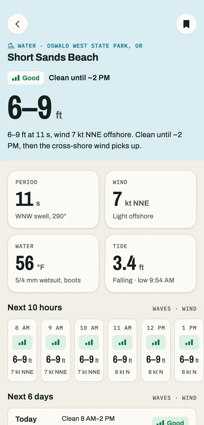
Go surf. Short Sands Beach is good until 2 PM.
Reports built for each sport
The numbers that matter for your sport.
A surfer and a hiker don't read the same forecast. Each report leads with the one number that decides the day, then shows the rest.
-
Water
Surf and paddle
Wave height · Swell period and direction · Wind · Water temperature · Tides
-
Wind
Kite, windsurf, wing
Wind speed · Gusts · Direction
-
Trail
Hike, trail run
Temperature · Chance of rain · Wind · Sky · Sunset
-
Snow
Ski, snowboard
New snow · Snow level · Summit wind
The week ahead
Hour by hour, then day by day.
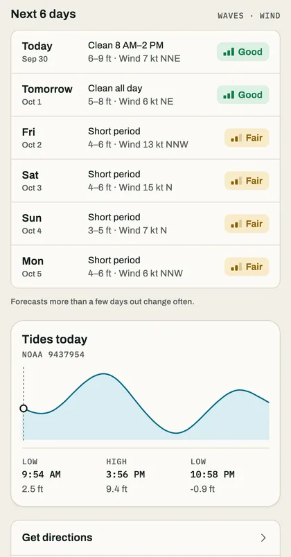
Ratings for the hours ahead and a day-by-day outlook for the next six days. If a better day is coming, the report says so.
Water spots add the day's tides from a nearby NOAA station. Trail spots add daylight and golden hour.
Notifications
Notifications that are worth it.
We only notify you when it matters: a warning at a saved spot, or a spot turning good.
- A morning report at the time you choose.
- A heads-up when a saved spot turns good, at most once a day per spot.
- Severe-weather warnings from the National Weather Service for your saved spots.
- Quiet hours, when only severe-weather alerts come through.
-
Morning report
2 of your spots are good today.
-
Short Sands Beach is good
4–6 ft, clean until ~11 AM.
-
High Wind Warning · The Hook
Stay off the water until 9 PM.
Examples
Explore
Every spot on one map.
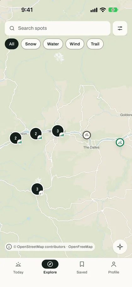
Browse the region, filter by sport and read each spot's rating on its pin. Search by name, or show only what's good right now.
Your location is optional. If you share it, it's used on your phone to show the spots near you, and it stays there.
Honest about its data
We never show a rating from data we couldn't refresh.
Every report shows when it was updated and where its numbers came from. When the data is out of date, the report says so instead of guessing.
-
Rebuilt every
30 min
Reports are rebuilt from the sources every half hour.
-
No data after
2 hr
A report older than this shows No data, not a stale rating.
-
No signal
Saved
Reports are kept on your phone, so the last one is there offline.
-
National Weather Service
Forecasts, observations and official alerts.
-
NOAA National Data Buoy Center
Waves, swell and water temperature from buoys.
-
NOAA Tides and Currents
Tide and current predictions.
-
OpenFreeMap and OpenStreetMap
The map. Data © OpenStreetMap contributors.
What we're aiming for
A report you can trust at a glance.
-
01
An answer, not a dashboard
The first thing you see is the call. The numbers behind it are there when you want them.
-
02
Always say why
Every rating comes with its reason in one plain sentence, so you can disagree with it.
-
03
Never guess
If the stations can't be reached, the report says No data. It doesn't fill the gap with an old rating.
-
04
Only interrupt when it matters
A warning at a saved spot, or a spot turning good. Nothing else is worth a notification.
-
05
Readable by everyone
Color never carries meaning alone, and the app works with VoiceOver and large text.
-
06
A guide, not a guarantee
Conditions change quickly. The report points you to official forecasts and warnings, and leaves the decision with you.
Where
Starting in the Pacific Northwest.
57 spots across 9 regions of Oregon and the Columbia River Gorge at launch.
- North CoastAstoria to Lincoln City
- Central CoastNewport to Florence
- South CoastCoos Bay to Brookings
- Columbia River GorgeCascade Locks to The Dalles
- Mt. HoodGovernment Camp and the mountain
- Portland & Willamette ValleyPortland to Eugene
- Central OregonBend, Sisters and the Cascades
- Southern OregonRogue Valley to Klamath
- Eastern OregonBlue Mountains to Wallowas
Also
The details.
- Light and dark appearance.
- Imperial or metric units.
- Works with VoiceOver and large text.
- Layouts for iPhone and iPad.
- Look around first, with no account.
- Sign in with Apple, Google or email to keep your spots on every device.

Coming soon to iPhone, iPad and Android.
The store links will appear here when the app is released.
- Coming soon toApp Store
- Coming soon toGoogle Play